Category: Transit Ideas

  • Starting A National Rail Electrification Plan

    Starting A National Rail Electrification Plan

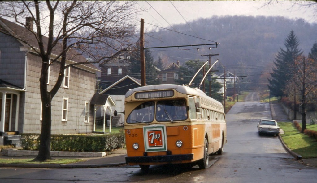
    Something momentous may be about to happen in United States passenger rail: Amtrak is going to gain electrified trackage. If recently-released proposals for $424M worth of passenger rail improvements in Indiana and Illinois are realized, regional and long-distance Amtrak services between Chicago and Northwestern Indiana will shift their route from the Norfolk Southern’s congested Chicago Line to the electrified, passenger-only South Shore Line and Metra Electric District. If Amtrak trains do wind up using the route, the 84km (52mi) from Chicago to Michigan City, IN will be the first addition of electrified track to the Amtrak network since 2000, when Amtrak electrified the 155mi stretch of the Northeast Corridor from New Haven to Boston in preparation for Acela service. (The Keystone Line to Harrisburg was re-electrified in 2006 after its infrastructure fell into disuse, but because the infrastructure remained in place, I’m not counting that here).

    At the same time, Amtrak is planning another major shakeup for trains on the East Coast, which will see the iconic, but very aged, Amfleet cars replaced with dual-mode trainsets capable of running off of overhead wires or a diesel engine. Dual-mode trainsets do not expand electrification themselves but, as will be discussed later in this post, can help facilitate extensions of electrification from main lines to their branches.

    That Amtrak’s proposed route move is their first gain of electrified trackage in 20 years shows how rare large-scale rail electrification projects have become in the United States. Since the aforementioned Amtrak project in 2000, only 53 miles of new electrification have been added to main line rail tracks in the United States for Denver’s commuter rail system; another 51 miles are currently being added as part of Caltrain’s Modernization Program. Electric traction is, by far, a superior way to power trains than diesel locomotives, and if we want U.S. passenger rail to be better—which, for the sake of both the climate and social equity, it must be—we need to electrify more of our railroads. Likely as a product of post-electrification service improvements, electrifying rail lines has been shown to increase positive public perception of rail travel and, as a result, rail ridership.

    Neither the proposed route shift in Northwestern Indiana nor the Amfleet replacement is a large-scale electrification project. But both absolutely can and should serve as a springboard to the wider expansion of electric traction in U.S. passenger rail, beginning with the electrification of lines owned by Amtrak or state governments (as opposed to freight-hauling Class I railroads). There are three strong candidates for immediate electrification: the Chicago–Detroit Michigan Line, the New Haven–Springfield Line, and the Washington, D.C.–Richmond, VA RF&P Subdivision. Alongside already-planned rolling stock and route upgrades, these three electrification projects should kickstart a wave of further electrification, and improved passenger rail, around the country.

    Expanding Electrification From The Midwest

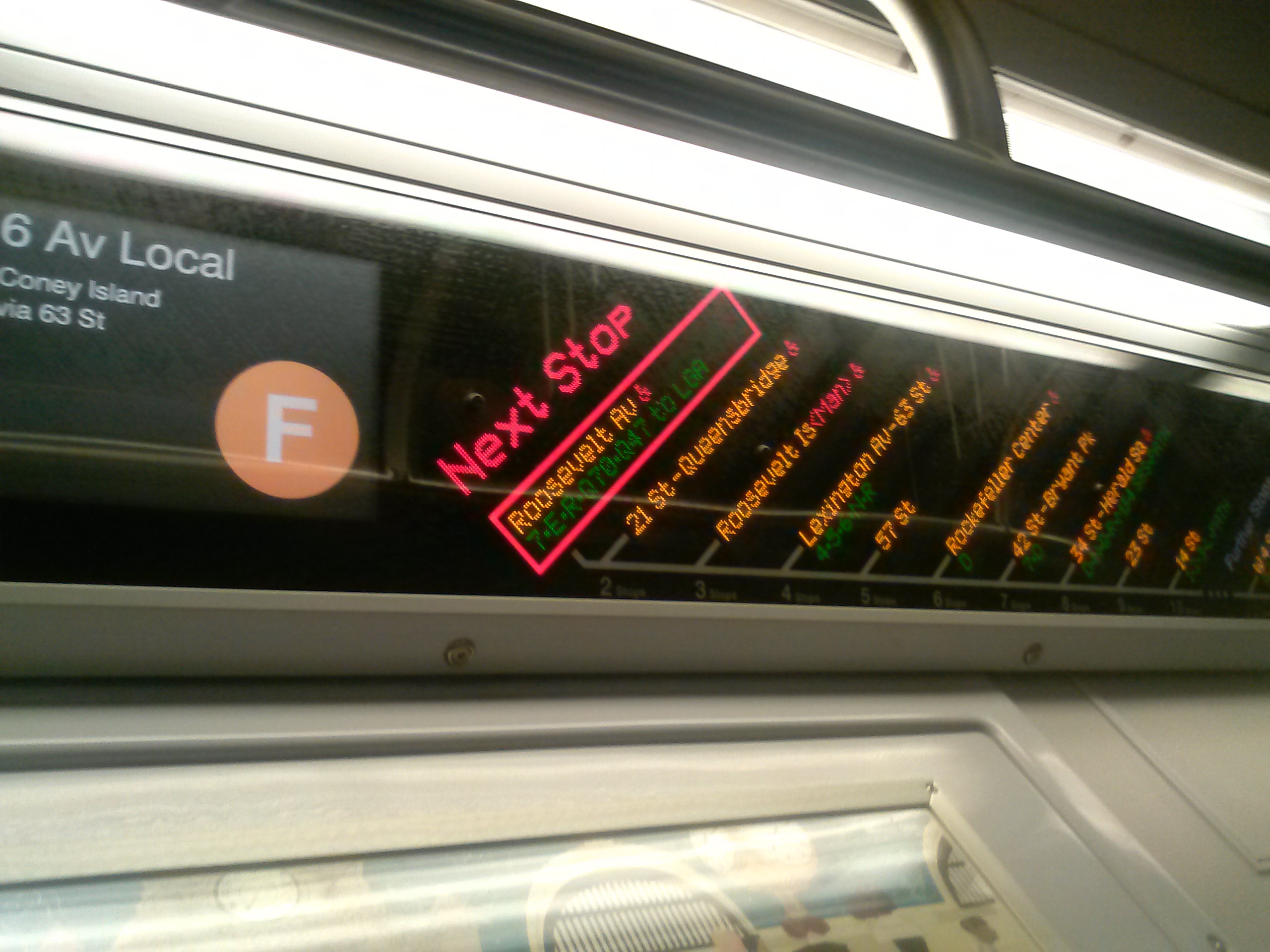
    The Chicago Access/Michigan East Program proposes to shift Amtrak service from freight railroad lines to tracks which will only be shared with other passenger rail service. For the most part, this is a hugely positive change that will hopefully reduce the unreliability that plagues Chicago-area Amtrak services and facilitate higher frequency of intercity trains from the Chicago hub.

    Potential vision for Metra through-service at Chicago Union Station, which will be made possible by Amtrak’s proposals to connect Union Station to the Metra Electric and Rock Island Lines via the St. Charles Air Line. This connection should be electrified! (image)

    One potential downside of the proposal is the possibility that regional and intercity trains get in each other’s way. Intercity trains could be delayed by regional trains’ more frequent stops, and the frequency of regional trains could be hampered by slower intercity trains. Running Amtrak trains under electric power is one effective way to mitigate this issue. Electric trains can accelerate faster, ensuring that Amtrak travel times are not lengthened by the move to the South Shore Line, which is longer and curvier than today’s Chicago Line route, and additionally preventing delays to regional trains at station stops. Another potential conflict point is the approach to Chicago Union Station, where a new ramp will be constructed to connect the station to the Metra Electric lines via the existing St. Charles Air Line. Amtrak’s grant application for the Chicago Access program also suggests that this new connection could host a shuttle service between O’Hare Airport and McCormick Place, through Union Station. It is crucial that this service, as well as Amtrak’s services, be electrically-powered. As electric trains have better acceleration and gradient performance than diesels, a ramp built with electric trains in mind can be shorter than it would need to be for diesels, minimizing construction costs. Lastly—but very importantly—more diesel trains mean more air pollution in the center of Chicago and in Union Station itself, which already has issues with poor air quality.

    An Amtrak electric district in Indiana and Illinois should quickly be expanded. The best candidate for immediate electrification is the Amtrak-owned Michigan Line, which connects Northwestern Indiana with Kalamazoo and Detroit. Parts of the Michigan Line are already set up for 110mph running; higher-performance electric trains would better take advantage of higher-speed track, and shorten travel times between two of the Midwest’s largest metropolitan areas. With the new route from Indiana to Chicago already electrified, Amtrak could quickly run large sections of their Michigan services under electric power. Amtrak owns the Michigan Line as far as Kalamazoo, as they do the Northeast Corridor, so electrification work would not be subject to the hostility it receives North America’s freight railroads. (Between Kalamazoo and Dearborn, outside Detroit, the line is owned by the State of Michigan but maintained by Amtrak).

    Map of the Amtrak Michigan Line. Between Michigan City and Chicago, Amtrak trains will be shifted to the South Shore Line under recent proposals. (image)

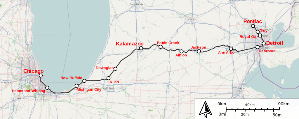
    If Amtrak can replicate the practices it used in the New Haven–Boston project, they might be able to keep construction costs close to that project’s not-unreasonable $3M per kilometer. At this cost, electrifying the 230km (143mi) Michigan Line from Chicago to Detroit would cost $690M. (The other suggested electrification projects in this post will also assume this cost). It should go without saying that this investment should be accompanied by improvements in service in order to be worthwhile. Chicago to Detroit services should probably be running about every 2 hours at least, and sections of the line should see more frequent service, such as Ann Arbor to Detroit if the long-proposed regional rail service ever gets running.

    Some of Amtrak’s new intercity trainsets (to be discussed in more detail below) will be dual-mode. There are no plans currently to send dual-mode equipment to the Midwest—this should change, and Amtrak should swap some of their Chicago-based diesel locomotives for dual-mode or electric types. The exact details of the new Siemens dual-mode trainsets are not yet fully known, but based on renderings (and speculation) it seems that it should be feasible to swap the new dual-mode locomotive variant on to the Midwest trainsets. (This would allow existing diesel locomotives to be released to increase service in unnelectrified territory, or to start new services entirely).

    A Brief Note On Voltage

    The South Shore Line is electrified at 1500V DC, a standard not used almost anywhere for new electrification of mainline rail. A conversion of the route to the modern 25kV/60Hz AC standard should be on Amtrak’s and Metra’s radar for medium-term investment. Use of 1500V DC for intercity mainline rail is not unheard of—it is widespread particularly on France’s legacy routes south of Paris—so the upgrade may not need to be made immediately, depending on the capabilities of Amtrak’s new rolling stock, but should be made soon. (Of course, if electrification is expanded to currently-unnelectrified tracks on the South Shore and Metra Electric route, or to Union Station, those expansions should use equipment that can handle 25kV power in anticipation of a change in voltage).

    Addendum on rolling stock and voltages, lifted from this Twitter thread: Rolling stock for South Shore line running would need to run off 1500V DC. In the interim, DC capability should be added to Amtrak’s APV power cars so they can run immediately off of the South Shore power supply. This seems easier for a few reasons than trying to force AC conversion of South Shore before the opening of Chicago Access. But part of any long-term plan should involve conversion to 25 kV AC everywhere, including South Shore and Metra Electric.

    Expanding Electrification From The Northeast Corridor

    Amtrak’s new intercity trainsets for the Northeast Corridor (NEC) will employ dual-mode locomotives capable of running off of a diesel engine or overhead electric wire (or a battery, on a handful of sets for New York services). The use of dual-mode trains eliminates the time-consuming engine change for trains which run through from the electrified NEC to unnelectrified lines further south and west.

    Diagrams of Amtrak’s new NEC intercity trainsets, to be built by Siemens. (image)

    Dual-mode trains are not perfect or an ideal solution—as has been discussed in great length and detail on Transit Twitter. However, the use of dual-mode trainsets for intercity and medium-distance trains does have the advantage of flexibility as electrification advances. Because they can switch between electric and diesel power on the fly, they can take advantage of electrification as it is extended incrementally, without requiring engine change points and electric maintenance facilities to be moved. We should take advantage of this dual-mode flexibility not as an excuse to forego further electrification—as I fear may be the plan—but to begin incremental expansions of electrification outwards from existing electrified territory in the Northeast.

    There are a couple of candidates for immediate electrification extending from the Northeast Corridor. The first is the New Haven–Springfield Line, which branches from the NEC mainline at New Haven, CT, and runs via Hartford to Springfield, MA. Recent investments have led to an hourly-ish service on the line between Hartford and New Haven, and the whole line has seen upgrades to track and stations. The logical next step is electrification. The line is relatively short, at 62km (100mi), and with several new stations either under construction or proposed, its frequent stops make the route particularly well-suited to electrification. At $186M, electrification would cost significantly less than the total investment so far in improvements to the New Haven–Springfield Line ($769M). The benefits of switching from diesel to electric trains can be found very locally; the other intra-Connecticut regional rail service, Shore Line East, recently replaced their aging diesel trains with EMUs, and are adjusting their schedules to account for EMUs’ superior performance.

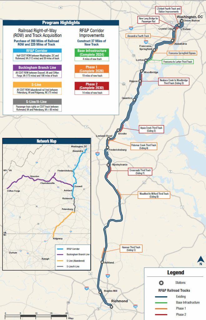
    The second is the 197km (123mi) extension of the Northeast Corridor from Washington, DC, via CSX’s RF&P Subdivision, to Richmond, VA. Since the 2000s, Amtrak has been incrementally improving service in Virginia, expanding their network and adding new services, but truly frequent service has been held back by the capacity constraints caused by sharing tracks with freight rail, particularly on the 2-track Long Bridge between DC and Alexandria. These issues are currently being addressed through a $1.9B upgrade program led by the State of Virginia, which will also be purchasing the parts of the right-of-way between DC and Richmond from CSX.

    Electrification between DC and Richmond, which should cost $591M, would not only benefit intercity and long-distance Amtrak trains. It would also be a major upgrade for regional rail services between DC and the Northern Virginia suburbs, currently provided by Virginia Railway Express (VRE). In addition to the built-in benefits of electrification, having VRE services under electric power would remove a major obstacle to regional rail services in Virginia and Maryland running through DC—something Maryland’s government is interested in doing, but which absolutely should not involve them continuing to run diesel trains on the electrified NEC.

    Conclusion: A “Rolling Program” of Electrification

    At a cost of $3M per kilometer—the cost of Amtrak’s most recent electrification project—this initial program of expanded Amtrak electrification could be completed for $1.9B, and would add 434mi of electrified track to the national network. This is roughly equivalent to the entire Northeast Corridor (464mi), effectively doubling Amtrak’s electrified trackage.

    I suggest the three lines above for electrification not because they are the only lines in the country deserving of electrification—far from it—but because by using Amtrak- or state-owned track, they are the simplest projects to achieve, and importantly, because they provide a solid foundation upon which to further expand electrification. For example, electrifying the RF&P may alleviate current skepticism towards electrification among planners of the S-Line—and in turn might make attractive further electrification of the North Carolina Rail Road line to Charlotte. Electrification around Chicago may encourage Metra to finally electrify their large suburban network, the busiest outside of the New York area.

    We should be aiming for the electrification of this full network. Starting with the busiest section—DC to Richmond—is necessary to build momentum for additional projects. (image)

    In the United Kingdom, advocates and politicians have called for the establishment of a “rolling program(me) of electrification,” in other words, a continuous flow of new electrification projects around the country, delivered as part of a long-term strategy. That is precisely what we need in the United States. Establishing domestic expertise on electrification and a supply chain for components help reduce procurement costs and avoid repeating past mistakes in new projects (which will stave off the cost overruns that too often plague our infrastructure projects). If the country can become good at delivering electrification projects, it is easier to make the case for funding new electrification projects to governments at all levels—and we end up with valuable momentum to continue increasing the size of the electrified network. The reduced costs that a rolling plan can provide will also help to make electrification more attractive to transit operators that would benefit, and have expressed interest, like the MBTA.

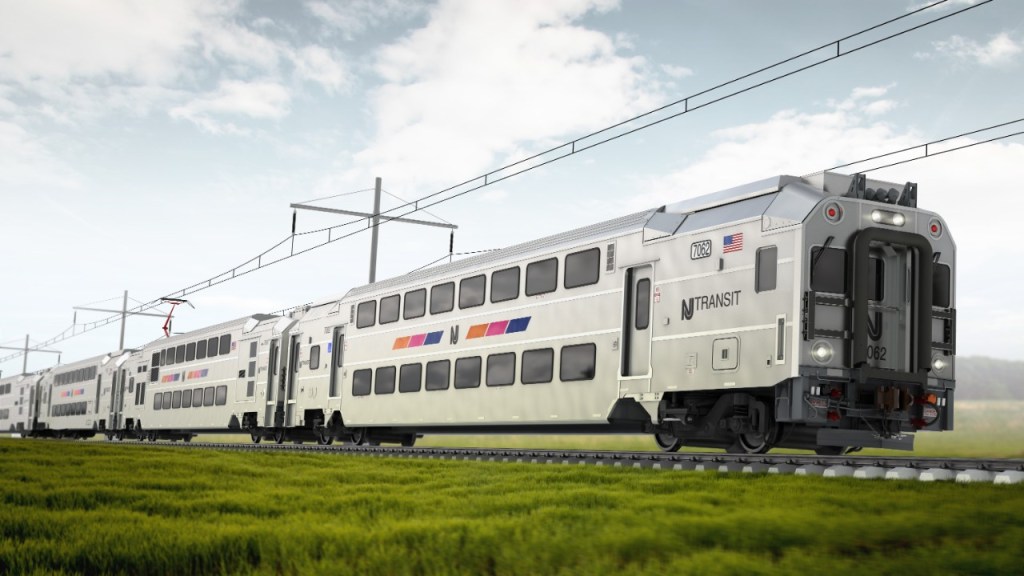
    This is also a good time to think about expanded electrification because, if a few rolling stock stars align in the coming years, there may be surplus electric equipment around to provide service on newly-electrified lines without the full cost of new rolling stock. Amtrak’s existing electric locomotives, the 2010s-built ACS-64s, have years of life left in them but many are about to be made redundant by the new intercity trainsets. New Jersey Transit (NJT) has ordered new Multilevel EMUs to replace the aging Arrow cars, and their contract with Alstom includes options for over 800 additional cars on top of the current order of 138. If the new EMUs prove a success, NJT could theoretically opt to order more cars and sideline some of their ALP-46 electric locomotives—which, at 20 years old, also have more life left. Any surplus electric equipment should be used to replace diesel locomotives on suburban or intercity rail networks—which means now is the time to strategically expand electrification.

    Right now, the United States is missing a long-term vision and strategy for rail electrification. Even as recent infrastructure funding has inspired visions of expanded passenger rail, additional electrification—and by extension, faster, more reliable, and less polluting trains—has been left off the table. Amtrak should begin working to electrify the track it owns, lobbying state governments to fund electrification of their tracks, and take advantage of the (unfortunately all-too-rare) rail-funding-friendly federal administration to get the ball rolling on large-scale electrification.

  • Improving Subway Cars’ Exterior Signage

    Improving Subway Cars’ Exterior Signage

    (This post is an elaboration of a Twitter thread on the same topic).

    Digital destination signs have occupied their familiar place on the side of subway cars for nearly thirty years. In the early 1990s, the original rollsigns on the R44 and R46 cars were replaced with digital displays, and since then, digital signage has been included on every subsequent order of new subway cars. There are clear advantages to using digital signage, especially when it comes to flexibility. Rollsigns—which once dominated the subway fleet, and remain on many older subway car models—need to be changed manually, and individually, so are easily rendered inaccurate when a train’s destination changes in service (which, on a system where services are diverted as easily and frequently as they are in New York, is often). In contrast, digital signs can be programmed to just about anything and, importantly, can be easily changed on the fly. But in the thirty years they have been in use, the basic design of these signs has remained almost entirely unchanged: one box on the left of the screen identifies the line the train is operating on, and another box to its right cycles through the train’s destination and routes taken.

    The Problem

    There are a handful of simple subway routes: they mostly keep to themselves, can claim an entire line as their own, and can’t really be diverted on to others—the L, 7, G, or the shuttles are the best examples. On lines like these, single-line destination displays might be perfectly adequate. But the majority of subway routes share lines with one another. The M, for example, is a service that stitches together four subway lines: the Queens Blvd, 6th Avenue, and Myrtle Avenue lines in their entirety, and part of the Jamaica line (and if you count the 53rd Street Tunnel as its own line, five total lines). This has to be communicated through rotating lines of text on destination displays. To keep things from getting too overwhelming, the MTA seems to limit the number of text rotations to three (see example GIF below). The result of this is that a lot of really important information about where trains are going—and where they’re stopping on the way—has to be compressed down to fit on three lines. In the M train example, below, “6 Av Local/53 St” might make sense to those more familiar with the route, or with the subway system, but would not be as easy for someone not used to subway geography to understand.

    The Solution

    I think the solution here is really obvious: destination signs simply need a second line. This can be done by retrofitting new displays on the New Technology Trains—the R142s, 142As, 143s, 160s, and 179s—within the existing window display frames. With a second line, the train’s destination—arguably the most important information, as this confirms to riders that they are getting on a train in the correct direction—can be displayed constantly on the top (first) line, while route information rotates on the second line. If we were to keep the second line to 3 rotations, as the signs are currently, we could clear up a lot more information: that the M train runs via 53rd Street can be displayed separately—which makes a lot more sense if you are less familiar with subway geography but going to either of the M stations with “53rd Street” in their name.

    But the much larger strength of the second line is how much additional information can be clearly communicated—and how much more flexible it can make subway signage. For instance, we could display a train’s next stop at platforms shared between local and express or skip-stop trains (such as Marcy on the J) or where lines branch (like 59th on the A/B/C/D)—an important way for riders to ensure they board the right train. (This also applies when a service makes an unscheduled express run). The second line can also highlight that a train is on diversion—like a 6th Avenue service running via 8th, or vice versa—while keeping the train’s final destination in view at all times. This can help to reduce the moment of confusion which invariably occurs when passengers find a diverted train arriving at their platform. Ideally, new signage should take advantage of full-color LEDs, or use an LCD, to further emphasize important information or unusual service. I’ve shown diversions and unplanned changes, as well as service to important destinations like JFK Airport, in yellow. Part-time express service, such as the F in Brooklyn, could be similarly highlighted in yellow, or in the line color (though this may not always be practical). Full-color displays might seem extravagant in comparison to what we have now, but both color LED and LCD displays are becoming cheaper and more ubiquitous (the MTA have retrofitted LCD ad panels into a handful of subway cars, and are ordering new cars with them pre-installed).

    With the recent (and welcome) advancements in platform information displays, it may not seem necessary to enhance those on the trains themselves. For a number of reasons, I would disagree: firstly, even in an ideal world, it would be difficult to guarantee that there is always a real-time display within view anywhere on any platform. Secondly, clear information on trains serves as an important verification of platform displays. While platform screens such as the one pictured to the right will always be more helpful for general journey planning and communicating a train’s entire route, on-train displays can serve as a final confirmation to passengers that they are about to board the correct train. Though this can be done with the displays as they are, it would be much easier to make this confirmation at a glance with a two-line display (and of course, there are those times when you’re running for a train and may not be able to wait as long for the display to cycle through!)

    Platform information displays at Court Square on the 7 line.

    Conclusion

    FIND display on an R160 car. (image credit)

    Technology has progressed a lot since the 1990s, and this should be reflected in the rider experience of our subway cars. The most recent such advancement was introduction of the Flexible Information Display (FIND) maps on the R160s in 2006. The R211 cars, fresh from the factory this year, take some further technological steps, restoring the subway’s iconic bullet line indicators in full-color LEDs and refreshing the FIND displays, but they unfortunately fall just short of what could be a comprehensive re-think of subway information.

    Close-up of the destination sign on the static mockup of the R211. (image credit)

    Antenna Design‘s 2017 static mockup of the R211 cars—which are planned to replace the digital display-pioneering R46 cars within the next few years—addressed the display space issue with two lines, one each for the destination and service pattern. But the production cars (at least the few which have arrived in NYC recently for testing) deviate from this design, returning to the more familiar two rectangles, though with altered proportions as a result of the new cars’ shorter windows. From the limited number of glimpses that have been made at the R211s’ signage in action, it appears that, although the displays have two lines because of size constraints, information will be displayed in the same fashion as on older, one-line displays. These size constraints make the type of displays I propose difficult on the R211s—but I think making the route bullet smaller in exchange for more text space on remaining cars would be a worthy trade.

    Destination sign on production R211 car #4060, displaying an identical sign (A to Far Rockaway). (screenshot taken from video by NYC Transit).

    When electronic displays were introduced on the R44 and R46 cars, it was part of a mid-life overhaul the cars received after 20 years of service. That is about the same age as the 2000s-era New Technology Trains are right now. It’s not known whether they will receive a similar mid-life overhaul—though, again, the pace of technological change probably warrants it. It’s worth noting that the MTA has experimented recently with upgrading the displays on a handful the 7 line’s R188 cars, but made no changes the fundamental design. The limitations in the design of earlier displays make sense considering the technology available in the mid-1990s. But as a new generation of subway cars arrive, and the previous generation reach the middle of their service lives, it’s past time to take advantage of more recent technology to make subway navigation easier and improve riders’ experience on public transit.

  • Reopen The Subway Bathrooms

    Reopen The Subway Bathrooms

    One of the many things made suddenly more obvious by the COVID-19 pandemic was the dire lack of public restrooms in New York City. As shops shut their doors to the public to curb the spread of the virus, it quickly became harder than ever to find any open bathrooms in the largest city in the United States. Further exacerbating this situation was the fact that, shortly after the start of the pandemic in New York City, the remaining public restrooms in subway stations were closed.

    It was not always this difficult to find a bathroom in New York City. There were once hundreds of public restrooms scattered across the city’s 472 subway stations, though only several dozen remain. For years, the subway’s remaining public restrooms have been held at arms-length, both by the MTA—which provides little information about where they can be found—and by much of the riding public, few of whom use subway restrooms, but may hear of their existence through occasional articles on their dilapidated condition.

    Right now is the time to reopen the bathrooms in the subway system—not just from the temporary pandemic closure, but as an intentional and permanent provision of good public restrooms to New Yorkers. New York’s would be far from the first subway system in the world to incorporate public restrooms for its riders. As with many other much-needed improvements to operations, governance, and rider experience, it is important that we look to peer subway systems and cities to inform the re-opening of restrooms in the subway system, and plan for a future New York where the closest public restroom is always just a few minutes away.

    Subway Restrooms During COVID

    Even if they have been closed to the public for decades, subway restrooms are usually pretty easy to spot in stations, once you know what to look for: typically paired, identical doors, often immediately on the platform-side of fare control. Many retain their original mosaics or plaques, above or next to the doors, such as this example from Astor Place on the Lexington Avenue Line (above). The still-active bathrooms are not advertised ostentatiously, marked only by pretty small, standard-issue MTA signage. Those closed to the public may still serve a purpose: some remain restrooms, open only to staff; some are used as storage rooms; and some have been transformed entirely, like the former women’s restroom at Astor Place, which was recently a newsstand.

    Active (but temporarily closed) public restrooms at 14th Street-Union Square.

    As the COVID-19 pandemic took hold over New York City in March 2020, subway restrooms were closed as a way of mitigating the spread of the virus. They have all remained closed since; despite increasing calls for their re-opening, the MTA has been non-committal on when they may be unlocked. In a growing trend of political hostility towards homeless New Yorkers, and heightened fears over crime and safety in the subway system, there is a worrying possibility that the agency may be hoping to silently keep bathrooms in the subway closed indefinitely. That would be wrong. New York City, like many US cities, already has a dearth of easily-accessible, truly public restrooms. The subway system—a public space where New Yorkers spend a considerable amount of time, and which already has the required infrastructure—is the ideal place to begin developing a robust network of public restrooms in New York.

    Public Restrooms In NYC: A Brief History

    Public restrooms were an important element of New York public works projects in the era of the New Deal, which provided funding for the construction and renovation of public restrooms. During the 1970s and ’80s, many public facilities, including restrooms, were closed, as a result of municipal near-bankruptcy and fears of crime. Since then, there has been no concerted effort to build the city’s public restrooms back to their New Deal-era peak. The most recent effort—the Automated Public Toilet (APT) scheme launched by the Bloomberg administration—stalled several years ago. Only five of the twenty units built were installed as of 2018, and the remainder continue to sit in storage. The de Blasio administration has shown little interest in expanding access to public restrooms in the city, but did very briefly provide portable restrooms during the early months of the COVID pandemic. There have also been one-off projects by Business Improvement Districts to build public restrooms, such as the very highly-rated facilities in Greeley Square and Bryant Park.

    The Rise & Fall Of Subway Restrooms

    Former men’s restroom at Astor Place, part of the original, 1904-built IRT subway. Though closed to the public, this remains a restroom for staff.

    The history of restrooms in the subway system follows a similar trajectory. The New York City Subway, constructed primarily between the 1900s and 1930s, was built with hundreds of public restrooms across its hundreds of stations. 1940 seems to have been the peak of the subway bathroom, with 1,676 working toilets in the system (and, according to a report, only 12 “unclean” ones). By 1970, as years of poor maintenance had caught up with subway infrastructure, their conditions were deteriorating seriously: “dirt, corrosion and uncollected garbage greet each traveler as he enters the stations. Flaking paint from ceilings and missing wall tiles complete the picture. Conditions in restrooms are equally bad, with many having inoperative fixtures.” In 1982, the Transit Authority locked the vast majority—75 percent—of subway restrooms to the public. Citing decreasing use, vandalism, and problems with safety, the agency reduced the number of public subway restrooms from 788 to 204, the remaining restrooms mainly located at terminals, major interchanges, and other busy stations. Many restrooms remained open for transit staff only.

    Since then, there have been only sporadic attempts to revitalize subway restrooms. In 1994, the MTA ran a pilot program at three busy stations—Grand Central, 34th St–Herald Square, and Jamaica Center—to improve the cleanliness and safety of subway restrooms. Staff monitored restrooms every 15 minutes, cleaning and maintaining facilities as necessary. At the time, the pilot cost $287,000—about half a million 2021 dollars—for nine months. “If successful,” the program would have been extended, but this seems to be one of the many pilot programs lost to history.

    The improvement of subway restrooms became the subject of agency discussion more recently. The 2017 Fast Forward Plan included a commitment to “improve restroom availability and servicing.” The agency documented progress towards these goals in reports from mid-2018 (on the “overhaul” of restrooms at two stations) and late 2019 (on the reopening of a restroom at the 5th Avenue–53rd Street station and cleaning and repairs at several other station restrooms); this brings us to shortly before the arrival of COVID-19 in New York City, and the resulting closure of all public restrooms in the subway. Fast Forward plan was put on hold last year because of COVID-19’s impact on transit finances, and significant changes in agency leadership since the drafting of Fast Forward throw into question the degree to which the plan will guide the agency’s post-pandemic strategy. The last the public heard about the re-opening of subway restrooms was at the MTA’s June 2021 board meeting. Then-NYC Transit Authority President Sarah Feinberg stated that restrooms should be reopened, but was non-committal about when that would happen, saying only that long-standing issues such as homelessness on the subway should be addressed first.

    Public Restrooms On Other Metro Systems

    There is something of an age divide that determines whether a metro system was built with public restrooms. Older systems—such as those of New York, Chicago, and Boston—were built with them (Chicago, similarly to New York, closed theirs in the 1970s). Later-20th-century metro systems seem less likely to be built with public restrooms, or were built with fewer of them. (There are, of course, exceptions: public restrooms were built into San Francisco’s BART stations, though many have since been closed, and all 622 of Seoul’s Metro stations have public restrooms).

    This later aversion to public restrooms is exemplified in Mexico City where, in 1973, the director of their then-new Metro highlighted its lack of public restrooms as one of the many things that set their clean, modern system apart from New York’s increasingly-dilapidated one. Montréal’s Metro was opened around the same time—in 1966—and also did not include public restrooms (though there appear to be a small handful, which may have been retrofitted). The Vancouver SkyTrain—opened 1985—includes no public restrooms, and while its operator TransLink has said in the past that they would consider installing restrooms, they have made no concrete plans, and the upcoming Broadway subway extension will not include them.

    Public restroom at the Ho Man Tin MTR station, Hong Kong. (image credit)

    Hong Kong’s metro was opened a decade after those of Mexico City and Montréal, in 1979, and it too did not include public restrooms (though one of the reasons given for this decision was the high availability of public restrooms in the city’s commercial buildings). In 2007, MTR, the corporation which runs Hong Kong’s metro, considered retrofitting public restrooms to their network, but deemed this technically unfeasible as underground stations lacked the requisite sewage capacity and ventilation. However, in 2016, MTR announced a program to retrofit public restrooms to interchange stations by 2020, and appears to have largely accomplished this. Restrooms have also been included in all newly-built stations, and MTR has plans to add further restrooms in the coming years.

    Toronto’s subway has public restrooms, though only at interchange stations and terminals (and former terminals). In 2012—six years before his Fast Forward plan at the MTA would recommend similar steps—then-TTC President Andy Byford led an upgrade of the system’s restrooms. As well as the replacement of restroom fixtures, the TTC program increased frequency of cleaning from every 4.5 hours to every 90 minutes, and the frequency of “major” cleaning from weekly to five times per week. Availability of public restrooms is depicted on Toronto’s subway map. And though London’s transport network also lacks comprehensive public restroom coverage—they are mainly concentrated at outer-city, rather than central, stations—Transport for London does provide a very convenient Toilet Tube Map.

    Paris’s Self-Cleaning Solution

    Metro systems around the world illustrate that public restrooms work—but, crucially, they should be well-equipped and well-maintained. New York’s, prior to the pandemic closure, were not. In 2019, a station supervisor (cited in the article linked) said that restrooms at the Norwood–205th Street station) were cleaned three times per day. In both the MTA’s—and other agencies’, such as the TTC’s—past attempts to improve public restrooms, one of the key objectives was increasing the frequency of cleaning and maintenance. This sounds ideal, and it is, but the big downside would be cost: very frequent inspections of restrooms will cost a lot. The specific frequency may depend on the level of use of the station, and in some cases this maintenance may be incorporated into existing cleaning jobs, but increased restroom maintenance will almost certainly be an additional cost for transit agencies.

    Public restroom on Paris’s RER line A (image credit)

    A partial solution to high maintenance and cleaning costs could be to opt for automatically-cleaning restrooms. While New York’s brief experiment with these facilities on the street never gained momentum, such facilities—sanisettes—are extremely common on the streets of Paris, and the technology is also employed in public restrooms on the Métro and RER. According to the RATP–SNCF-run RER A Blog, these restrooms are inspected and cleaned twice per day, even at the busiest stations such as La Défense and Châtelet (presumably, the self-cleaning functions adequately take care of more frequent cleaning).

    Sanisettes For The Subway (And The Problem Of Costs)

    In the subway, individual sanisette units could be installed in the existing spaces of either active or closed restrooms, which are plentiful in the system.

    But the issue of cost is, as ever, not fully solved. Retrofitting self-cleaning restrooms to subway stations will come at a cost, and given New York’s history of construction costs, this is likely to be high. Street sanisettes in Paris cost about €200k per unit; similar units in Montréal cost CA$340k per unit, and CA$3.1m (CAD) for 12 units; but New York’s cost $500k to install in 2014. These costs include new connections to respective cities’ sewer systems, a cost which may be mitigated in subway installations, where restrooms already have sewer, and electrical, hookups. (That said, these savings could easily be negated by the required demolition of existing restrooms).

    Sanisette unit in Paris. (image credit)

    Maintaining the restrooms does not come without cost, either. Maintenance of Paris’s sanisettes—which takes place thrice-weekly at each unit—is handled by JCDecaux under contract from the city; for 420 sanisettes, the city apparently pays €6m per year, or approximately €14k per year per facility.* But New York’s APTs cost over twice that amount to maintain, at $40k per year in 2014. At Parisian costs, installing one sanisette-style unit at the 76 stations currently equipped with public restrooms would cost $18m, and $1.3m per year in maintenance. But at New York APT costs, this rises steeply to $38m for installation and $3m for maintenance—and that is before we get to expanding the number of restroom-equipped stations, which we should be doing. (In comparison, the MTA’s 1990s frequent maintenance pilot cost about $670k per year for six stations. The frequency of cleaning could probably be lower, but for just the 76 existing restrooms, the yearly cost would exceed Paris’s sanisette prices).

    These costs may seem high, but capital costs for better subway restrooms are not escapable. An alternative to automated units could be could be keeping and reopening subway restrooms basically as-they-are, but should be refurbished, which will come with capital costs, and would require higher yearly costs stemming from more frequent cleaning. Realistically, though, it is unlikely that the MTA would finance such a program at either Parisian or New York costs right now—and, at this nadir in city-state cooperation, especially on transit—equally unlikely that the city government would chip in.

    * (As of April 2020, the city was seeking a new holder for the contract, as well as the replacement of the facilities by 2024, so this may change).

    Conclusion

    The MTA should adopt a subway restroom improvement program, either installing new, self-contained units in existing spaces, undertaking refurbishments of existing restrooms, or a combination of the two, based on expected use at given stations. Restrooms should be more clearly signed in stations, and availability of restrooms should be added to the subway map (or otherwise listed in one location) as in London and Toronto. The case for readily-available public restrooms as part of city infrastructure has been made many times, and applies here. This is far beyond a matter of convenience—access to public restrooms is necessary for genuinely accessible public spaces, including transit systems. Given that these will be an important part of the city’s public infrastructure, it would make sense for the city to have a financial stake in such a program—but this will require a different political world here.

    Finally, facilities should be free. Hesitancy to provide public restrooms, or desires to place restrictions on their use, is commonly a product of hostile attitudes towards homelessness—thinking which should not be entertained. Paris made its originally-paid-access sanisettes free in 2006, specifically to allow easier access to homeless Parisians. Secondly, most existing subway restrooms are already located on the “paid” side of fare control—there is no need to apply a second “fare” that will accomplish little but make restrooms less convenient and accessible. Ideally, New York would have street-level, free, APT-style public restrooms distributed around the city, outside of the subway, as the sanisettes are—and we should have this. But using the space and infrastructure which already exists in the subway system is the best way of getting public restrooms across the city quickly and efficiently.

  • More On Multilingual Transit & Inclusive Wayfinding

    More On Multilingual Transit & Inclusive Wayfinding

    I recently wrote a post about how New York City’s transit system could be made more accessible by incorporating more multilingual signage and announcements. That post included a few examples of other transit systems’ (especially Paris’s) multilingual wayfinding. This post is an addendum to that, and is meant to serve as a catalog of multilingual transit around the world, and provide further suggestions for non-multilingual transit agencies, specifically New York’s, on how to (relatively easily!) create a more inclusive public transit network.

    Examples Of Multilingual Transit

    In The United States

    New York’s neighborhood-specific multilingual service change notices already make it one of the strongest multilingual transit systems in the country (even if the translations sometimes need some help). But provision of information in languages other than English does not extend to typical informational announcments or wayfinding signage.

    Houston‘s Metro announces arriving light rail trains, as well as bus routes and destinations, in English and Spanish. San Francisco‘s MUNI buses—seemingly so far on a trial basis—announce opening doors in English, Spanish, and Cantonese.

    Outside The United States

    The best examples of multilingual wayfinding in transit are outside of the United States. (And, generally, outside of the English-speaking world, with the exception of bilingual Canada). Bilingual signs with English translations are common, but systems which regularly employ trilingual signage are not difficult to find either.

    The Tokyo Metro (and associated JR and other mainline stations) provide the majority of signs in Japanese and English. Exits are generally distinguished with yellow signage (see Shibuya example, left) and transfers emphasize line colors (both examples). Platform and train announcements are also typically bilingual, as are the digital information screens common on trains (since these are coming to NYC—both retrofitted to current trains and on new fleet deliveries—the example provided by Tokyo is worth copying).

    (There are a lot of really good blog posts on the internet about wayfinding in the Tokyo Metro and across transit in Japan—such as here, here, and here—which I would highly recommend).

    Seoul Metro station signage, with line termini listed bilingually. Also includes distances in meters to station facilities! (image)

    In Seoul, most Metro signs and announcements are given in Korean and English. In at least one case—Metro Line 1 at Seoul Station—the station announcement with transfer information is made in four languages (Korean, English, Japanese, and Mandarin).

    The Hong Kong MTR system is also multilingual: all announcements on trains are made in Cantonese, Mandarin, and English, and all signs include Chinese and English text.

    The above systems all additionally employ symbology to direct riders towards important station facilities, such as exits, elevators, restrooms, and information kiosks. These systems also number (or letter, or in Tokyo’s case, both number and letter) their stations’ exits—this might reduce confusion among those unfamiliar to the system and the city, or to those who do not understand the given languages on signage (as exit numbers can be included on mobile maps).

    Even Metro systems without multilingual signs, such as Lisbon, use symbols for exits—arguably the most important information a rider should know upon stepping off the train. This is a contrast to systems which are heavily text-based, such as London and New York. Even when exit signs are visually distinguished—as New York’s and London’s typically are—what reason is there not to provide commonly-understood iconography in addition?

    Exit sign in the Lisbon Metro (image)

    Paris is one of the world’s more multilingual metro systems. The RATP provides most important announcements, in stations and on trains, in multiple languages. Some examples of Paris Métro (and RER) multilingual announcements include: momentary delays, arrival at a terminus, advice for traveling in hot weather, disruption to airport services, operation of shorter trains, notices of pickpocketing, and, of course, “mind the gap.” Signs in Paris are include some multilingual directions—for tickets and passenger information—and the RATP employs several methods to keep wayfinding accessible, such as symbology for station facilities, numbering exits, and line maps at platform entrances, which allow passengers to confirm they are on the correct platform to reach their station.

    Many more metro systems include basic multilingual signage. There are too many to list here, but some examples include those of Santiago, Dubai, Istanbul, Shanghai, Brussels, Madrid, and Rio de Janeiro.

    Back To New York

    The previous post had several suggestions for multilingual signage on New York City’s transit network. Those were to improve translation options on the MTA website, add multilingual informational announcements as in Paris, and clarify wayfinding. This post will have a few other more random ideas: some thoughts on clarifying wayfinding and making important information more accessible, and more on how and which announcements can be made multilingual.

    On The Subway

    Firstly: it should not need to take this much (somewhat awkwardly phrased) text to communicate to people where they can get information and assistance on fare payment (from an agent, at a 24-hour booth). Other metro systems get by with a commonly-recognized icon for information—which could easily replace the directions to “24-hour booths” within stations. If this icon was also labeled—ideally multilingually—one of the most important station facilities could be located by riders without having to scan rows of text. (Hopefully, rethinking the wayfinding around fare payment can accompany the rollout of the MTA’s new fare payment system throughout the next year).

    Accessible boarding area sign at 14 St-Union Square.

    Some busier stations include designated accessible boarding areas—typically sections of the platform which are level with the train floor. This is an example of a sign which should be translated, and supplemented with platform additional signage directing riders towards the accessible boarding area. These same directional signs should also direct people, using symbology, to the nearest elevators (if the platform has them, which, of course, it should).

    There are other wayfinding lessons which New York can learn from international metro systems. Route information on platforms would be welcome in New York. The previous-and-next stop signs used in Seoul and Tokyo may work well. Knowing the immediate next stop is often relevant on New York platforms which mix local and express service, while dynamic digital signs are better for full route information, given our system’s penchant for shuffling and diverting subway routes. Numbering or lettering exits is worth considering, but could very easily become more confusing than not, given station signs are already saturated with numbers and letters used to describe subway lines.

    Existing platform signs with route information should be considered obsolete. They are difficult-to-decode walls of text describing often-complicated and changing service patterns. Signage facing riders as they exit trains would be much better used to direct riders towards exits and transfers (this is already done at Times Square, though this sign could probably be made clearer). The Paris and Lisbon examples show how this type of signage working.

    Buses

    The MTA has recently added digital information screens and announcements to its buses. Generally, I think that the interface on these screens is due for an upgrade (as are the basic text-to-speech announcements), and this is an easy way of adding more inclusive navigational information to the bus system. Digital screens can easily cycle through various translations of information, and informational announcements on buses can be played in several languages as well (ideally, the choice of languages can be made based on the communities served by a given route—as the MTA already does with service change posters). As noted above, buses in Houston already announce their route and destination bilingually upon arrival at bus stops, and this is a good example to follow.

    Typical onboard digital screen (image)

    Conclusion

    In New York, we lag behind the rest of the world when it comes to multilingual accessibility and clear wayfinding. This is not difficult to change: printing signs and reprogramming digital displays is not a major capital expense, and does not involve construction, but can go a long way to improving the usability of transit for native New Yorkers, newcomers, and visitors alike. Issues like wayfinding have, understandably, taken a backseat in recent months, as transit in New York City and across the US have faced dire, at times existential, threats posed by the pandemic-related plummet in ridership. But a less-confusing transit system is one that people will be more eager to ride. If the MTA is considering a general refresh of the system’s wayfinding (and if not, they should be, it’s been a while), it is imperative they look to other systems’ examples of how navigating public transit can be more inclusive.

  • NYC’s transit should be more multilingual

    NYC’s transit should be more multilingual

    Cities, by nature, are multilingual. New York City (especially Queens) is one of the most linguistically-diverse places on Earth. On top of that, major cities such as New York attract (when there isn’t a pandemic happening) tens of millions of visitors every year from around the world, further adding to the number of languages being spoken in the city. The signs we use to navigate public transit should reflect this. On some transit systems this is already the case: signs and announcements may include translations into the languages of neighboring countries, and English in addition—but wayfinding on New York City’s transit, and many other US transit systems, is mostly English-only. Work to make public transit fully accessible must include the addition of multilingual signage and announcements to existing ones.

    The Paris Example

    Paris’ Métro and RER systems provide an example of how crucial information can be provided multilingually. Informational announcements—such as an unusually large platform gap at an upcoming station—are typically announced in at least three languages: French, English, and one of either German, Italian, or Spanish. (Announcements on Métro Line 1, which serves many of the city’s major tourist sites, also adds Japanese). This is carried over to more general platform announcements, such as advice for traveling in hot weather, and reminders to be aware of pickpocketing. Service interruptions or changes, such a suspension of trains to Charles de Gaulle Airport, or the fact that some trains are shorter than the platform length, are also provided in several languages.

    While our MetroCard vending machines offer multilingual interfaces, we could probably make more obvious that they are, in fact, fare machines: other than the scrolling LED sign (which is too often warning you that some functionality of the machine isn’t available) our MetroCard vending machines don’t actually advertise very obviously from a distance that they are where you buy fares. With the new fare payment system, OMNY, being rolled out, and the increasing de-emphasis on in-person fare transactions, we should look to follow international examples in making clearer where riders buy fares.

    What NYC Should Do

    To the MTA’s credit, a large amount of their temporary printed signage—such as posters for service changes—is multilingual. Typically, longer-term rather than short-term service changes are advertised multilingually; there are few examples of permanent multilingual signs.

    While the MTA website can be translated by Google Translate into any of the 109 languages on that service, this function is kept pretty hidden at the very bottom of the website’s pages—rather than at the top of the page, where it is easy to identify. While keeping Google Translate as an option for many languages may be beneficial, for those most commonly spoken in New York City, it might be worthwhile to have a dedicated site for those languages and a staff to ensure pages are translated accurately.

    We should add multilingual announcements and permanent information signs. New York’s subway system employs most of the typical subway informational announcements—mind the gap, et cetera—that are multilingual in Paris; they should be multilingual here as well. The ones which we don’t employ already—such as health advice for high-heat days, common on European systems—should be added, as they apply equally here. One of the reasons such system-wide general announcements have not been used in the past is because the system has, until relatively recently, lacked the infrastructure to push messaged from control centers to passengers in stations. There remain 76 stations on the subway which remain equipped only with analog public address systems, but the MTA has provided funding in the current capital plan (p.67) for these stations to be upgraded to the newer, centralized PA/CIS system. We should take this opportunity to provide better, and multilingual, informational announcements to passengers. In order to keep announcements reasonably concise, this would also entail shortening existing scripts of said announcements, which I don’t think anyone would complain about.

    Wherever possible, we should eliminate “walls of text” in wayfinding and informational signs, and lean more heavily on universally-recognizable subway symbology such as line bullets. The recent addition of digital strip maps to platform advertising screens is a hugely positive step in this direction: these allow passengers to see which stations arriving trains stop at—and whether their destination is served—without having to decipher text describing service patterns of each line. Reinforcing digital signage with more permanent line strip maps, which are employed by many metro systems, in certain locations would also be beneficial.

    Other information which can significantly change the way people interact with our transit system should be multilingual as well. One example of this—again, carried over from Paris—is alerting riders of shorter trains. There are many platforms on the subway which regularly serve trains shorter than their platforms’ lengths (the entire 6th Avenue line and Queens Boulevard local stops, for example, not to mention the infamous G train). At bus stops, information about frequency of buses, and about the span of service (for example, lack of late night or weekend service) should also be translated. The MTA already uses information about local demographics to translate service change posters into languages appropriate for given neighborhoods, and the same method should be carried over for bus stops.

    Implementation

    The example provided by Paris is not perfectly suited to New York City, given its normally extremely high degree of linguistic diversity, in addition to high tourism, but a similar implementation of multilingualism is still possible in NYC. In addition to multilingual service change posters in specific neighborhoods, the MTA also uses a common set of languages—English, Spanish, Chinese, Korean, Russian, and Haitian Creole—on some signs (such as some of the subway etiquette information, COVID-19 posters, safety posters, and legal notices). These should be the basis for multilingual announcements, and the combination used at specific stations, and on specific lines, can be determined by languages spoken in the surrounding community. The MTA should trial multilingual announcements on existing trains, and include them in the under-production R211 fleet. Additionally, focusing on quality translations of the MTA’s website into these languages would be a good way of making the website more accessible.

    In terms of more permanent signs, travel to and from the region’s airports is a likely need for visitors to the city. Information on airport travel from central stations should be translated on signs, and readily available on the website—visitors to the city who feel comfortable using public transit to get into the city for the first time are probably more likely to continue using it throughout their time in the city. At busier stations, safety information—platform gaps, advice not to wait in certain parts of platforms—should be translated on permanent signs.

    Conclusions

    Of all of the things which US transit agencies should to do increase transit’s mode share, this may seem relatively small. But that’s also (kind of) the point here: this is not a proposal for a major capital project or top-to-bottom upheaval of agency structure. Making signage and announcements multilingual is something that can be accomplished without great cost, but can go a long way to making both native New Yorkers and those new to the city and subway system feel more welcome and more comfortable with navigating the subway. Public transit is an important—for many, necessary—way of getting around the city and accessing employment or education. Inevitably there will be people who, because signage is confusing, opt not to use public transit, but taxis, ride-sharing services, or private automobiles instead, if they are able to—because they can be sure that they will reach their destination without confusion or stressful navigation. This is a failure of transit agencies to make their systems fully-accessible.

    This focused on New York and Paris because they are two systems which I’ve used. But the examples here could be—and should be—exported equally to other US transit systems, most of which have overwhemingly-English-only signage despite covering far more diverse areas. As a change which can be made relatively easily, multilingual signage deserves more attention from policymakers looking to expand the accessibility and appeal of public transit.

  • How Pittsburgh should electrify its buses

    How Pittsburgh should electrify its buses

    Electric buses are coming to Pittsburgh. The Port Authority of Allegheny County (PAAC) introduced a handful of battery-electric buses to service in the past year, and has placed orders for additional electric buses to be used on the forthcoming bus rapid transit service between Downtown and Oakland. Around the country, transit agencies are ordering electric buses, and subsidies for electric buses may become significant to federal transportation policy. With all the recent buzz around electric buses, you could be forgiven for thinking electric buses are new technology—but they’ve actually been around for decades. Different to the battery-powered vehicles in the press today, trolleybuses—electric buses which draw power from overhead wires—were once far more prominent, though only survive in a few US cities (Boston, San Francisco, Seattle, Philadelphia, and Dayton). Returning to the trolleybus—aided by some advancements in battery technology—is the best way to electrify the United States’ bus fleet, and Pittsburgh happens to be a great place to start.

    Quick aside on trolleybus history: Pittsburgh is actually somewhat unique in never having hosted trolleybuses. Many cities used trolleybuses as a sort of transition between streetcars and diesel buses, but Pittsburgh kept its streetcar network relatively late (into the 1960s) and went straight to diesel buses. However, nearby (but much smaller) western Pennsylvania city Johnstown did have a trolleybus network! (Ok, back to the point).

    Trolleybus in Johnstown, PA, 1967.

    Enter In-Motion Charging

    In Europe, cities and bus manufacturers have been combining trolleybus and battery technology, to produce in-motion charging (IMC), described by transit writer and best practices expert Alon Levy in a really good post on their blog Pedestrian Observations (which was the inspiration for this post). As noted here, in-motion charging works best “when relatively small electrification projects can impact a large swath of bus routes. This, in turn, is most useful when one trunk splits into many branches.” Pittsburgh’s extremely radial, trunk-based bus network could be particularly well-suited to trolleybuses which use IMC: putting up wires on a few major corridors could bring pollution-free bus service to much of the city.

    Trolleybuses For Pittsburgh

    The most important variable in planning an IMC network is the off-wire range of the vehicles. Longer-range IMC buses on the road right now include Kiepe Electric’s buses in Solingen, Germany, with an off-wire range of 18 km (11 mi). Kiepe is supplying the electrical equipment for Dayton’s new trolleybuses, which have an off-wire range of 24 km (15 mi), according to Dayton’s Regional Transit Authority. For the purposes of this, the hypothetical Pittsburgh IMC bus has an off-wire range of 20 km, which seems optimistic against most IMC systems in operation (which average between 5-15 km off-wire), but is probably do-able given the range of more recent buses.

    Prospective Pittsburgh trolleybus infrastructure map. Blue indicates first-priority corridors (explained below); green second-priority corridors. Map linked here.

    So where should the city be stringing up trolley wires? Here are the four corridors that I think would be the strongest, and which, together, would bring all-electric bus service to a large swath of the city:

    • Fifth Avenue: Wiring Fifth Avenue between Downtown and Craig Street would be sufficient for the four main Fifth Avenue routes to complete their trips and return off-wire. (The 71A & B take two different routes to Highland Park, an approximately 10 km round-trip; the C & D go to Wilkinsburg, just over 14 km). The 71A and 71C could also pick up wires on Centre Avenue (see below) which would further shorten their off-wire segments.
    • Forbes Avenue: The Forbes Avenue routes branch further east, in Squirrel Hill, so wires should extend to Murray Avenue (also good because getting up said hill would be a not-insignificant battery drain). The 61D to the Waterfront mall—a 12.4 km round-trip—should be fine, and the 61B might just make it to Braddock and back (18.8 km), but the 61A and (especially) C are >20 km round-trips, so are difficult without opportunity chargers (more on this later) at their outer termini.
    • Liberty Avenue & Butler Street: Wiring the Liberty Avenue spine between Downtown and Lawrenceville, around 33rd Street, would provide enough power easily for the 88 (11 km) and maybe for the 86 (19.6 km, though this could have help along Centre Avenue) and 87 (18 km). You’d have to extend wires along Butler up to about 55th Street to bring the 91 just within round-trip range; this is a bit far, but might be worth it because this section is shared with the circumferential 93 and the 87 (which would bring that route within safe all-electric range).
    • Centre Avenue: Between Downtown and East Liberty, Centre Avenue hosts several bus routes, and contains some significant gradients in the Hill District, which make it ideal as a trolleybus corridor. Wiring Centre Avenue as far as Negley or Euclid would provide sufficient power for the 82, and shorter sections of power for many more routes: the 54, 71A/C, 81, 83, and 86 all have segments on Centre Avenue and, with wires on other sections of their routes, could be made fully-electric.

    With the four corridors above, much of Pittsburgh’s East End would have fully-electric, pollution-free bus service. You may (rightly) point out that this proposed list is very East End-biased—this is really where the trunk/branch structure is strongest. In other areas of the city, the trunks are shorter and the branches longer, less desirable for IMC: this includes Carson Street in the West End and South Side, and North Avenue in the Central Northside.

    There are other corridors that would work. Wiring Second Avenue as far as the Pittsburgh Technology Center could make the 57, 58, and (maybe) 56 fully-electric; Murray Avenue hosts frequent service and is hilly so may be worth it. Short but busy sections of route where buses’ boarding times are long, such as Penn Avenue in East Liberty, can also work for IMC.

    The busways are the most glaring omission above—the reason they were left out above is because they are a real mixed bag of branch lengths, but enough branches could work with opportunity chargers at termini. If these were available, the busways would, of course, be very attractive routes for electrification—there are already several busway branches, such as the P17, P71, and G31, which are within the 20 km off-wire range. The other omission is the South Hills routes: these share a trunk (the Mount Washington Tunnel), but that is already wired for light rail, and trolleybus and light rail wires are not electrically compatible (trolleybuses need a separate return wire, rail vehicles do this through the running rails and therefore do not).

    Opportunity Charging

    Opportunity charging refers to the ability of vehicles to recharge briefly while they sit in one place, either at certain bus stops or at a terminal. The required infrastructure is a short section of wire which buses can connect to while standing, as employed in Solingen, Germany, and being considered in Gdynia, Poland. Placing opportunity chargers at terminals effectively doubles the off-wire distance that vehicles can travel, as they would only need enough battery power to make it to the terminal, rather than to the terminal and back to the wires. Opportunity chargers would allow, for example, the 61A & B to run to their terminals in Braddock (11.8 and 9.4km from Squirrel Hill, respectively), and the 61C to its terminal in McKeesport (15.9km). This would also open up several East Busway branches—including the P67 (a 9.7 km branch), P7 (14.7 km), and P68 (19.7 km)—to IMC operation, as well as the remaining West Busway branches, the G3 (16.9 km), and (maybe) the 28X (22.2 km).

    IMC opportunity charging “station” in Solingen

    Why We Should Want Trolleybuses

    Surely—you may be thinking—battery-powered buses could do this just as easily? And if they can’t now, at the rate technology progresses, in a few years’ time they might—so won’t all these wires will have been wasteful? Nope! There are several key, fundamental advantages of trolleybuses over batteries.

    IMC buses recharge their batteries while in service. This is a major difference with exclusively battery-powered vehicles, which need to stop and recharge with sufficient power to complete their next trip. This can take place at terminals, but only where terminal layovers are long enough to fully recharge; otherwise, battery buses have to be removed from service for some amount of time in order to recharge. The lack of ability for battery buses to recharge in service also means their batteries—a significant portion of the cost of an electric bus—need to be larger than those of an IMC vehicle. Battery-only vehicles are also less resilient: the range of battery-electric buses has been shown to suffer in cold weather and on steep hills—two things Pittsburgh is infamous for having in large amounts.

    Most importantly, trolleybuses are extremely well-proven technology. Cities around the world have operated trolleybuses for over a century, and there are numerous long-standing precedents from which Pittsburgh (or any other city) can draw best practices on trolleybus operation. Philadelphia’s pilot of battery-electric buses has come to a halt, while its 98-year-old trolleybus network soldiers on. Dayton has operated trolleybuses since 1933 and, as mentioned above, has recently invested millions in its continued operation. And these are just the two examples nearest to Pittsburgh—looking internationally can provide further guidance on trolleybus operations, especially with the addition of in-motion and opportunity charging.

    Re-Embracing The Trolleybus

    If we want to develop or expand trolleybus and IMC networks, we have to encourage them. Right now, the Federal Transit Authority (FTA) subsidizes purchases of battery-electric (as well as fuel cell and hybrid) buses through its Low or No Emission Vehicle Program. But this program doesn’t cover the infrastructure costs of hanging new trolleybus wires. As “fixed guideway” projects, agencies building new trolleybus wires need to apply for FTA Capital Investment Grants instead, placing them in competition with rail transit projects. This should be changed. The Clean Transit For America Act, which increases funding to the Low or No Emission Vehicle Program, should change the guidelines of the program to include trolleybus/IMC vehicles, as well as the cost of wiring. This is an important policy change not only on the off-chance that a city like Pittsburgh decides to develop a new trolleybus network—but because the strategy for bus electrification in existing trolleybus cities should be extending wires, not scrapping them for batteries, as Boston seems worryingly to be considering.

    PAAC’s first battery-electric buses, courtesy of the Pittsburgh Post-Gazette

    IMC can create a “best of both worlds” electric bus, mitigating the logistical issues with battery-electric buses while keeping their off-wire flexibility—and electrifying a lot of bus service without the cost of wiring every bus route in their entirety. The point of this post was not to say that battery-electric technology is bad; after all, it is advancements in battery tech that allow IMC to work, and which will allow it to improve in the coming years. But electrification of buses is imperative for the climate and for public health. There’s no time to wait for battery technology to advance to the point where it is able to carry an entire city’s bus fleet, at reasonable cost and with acceptable reliability. If we want large-scale bus electrification soon, it is time to re-embrace the trolleybus.

  • Pittsburgh should extend the T

    Pittsburgh should extend the T

    Every city has that transit fantasy: a proposal for transit along a certain corridor, or in a certain neighborhood, which goes back generations, has been the subject of numerous studies and proposals, but has yet to materialize. New York City has the Second Avenue Subway (though a short, first segment of it opened in 2017); Philadelphia, the Roosevelt Boulevard subway; Washington, D.C. has long wished for a Metro station in Georgetown; and San Francisco may one day get around to building a Geary subway. (I could go on).

    In Pittsburgh, the Downtown-to-Oakland corridor has been the subject of successive transit proposals. In the 1910s, the Pittsburgh Plan proposed a traditional heavy rail subway. The ill-fated 1960s plan for Skybus—an automated rubber-tired system—included a line to serve Downtown and Oakland. Thirty years on, a 1990s study considered a “Spine Line,” extending the “T” light rail tunnels which had since been built Downtown, to serve Oakland. As any Pittsburgh transit rider will know well, none of these proposals were ever realized.

    Drawing of proposed Skybus vehicle, www.brooklineconnection.com/history/Facts/Skybus.html

    Bus Rapid Transit: What’s Happening

    Last year, the Port Authority of Allegheny County (PAAC) received a federal grant for Bus Rapid Transit between Downtown and Oakland. This comes at the same time the agency is developing NEXTransit, its 25-year plan for transit in Allegheny County. For the first time in a Pittsburgh-area transit proposal of this scale, there is no plan for grade-separated transit between Downtown and Oakland — the agency has assumed that BRT will accommodate demand for transit in this corridor for at least the next quarter-century.

    Bus Rapid Transit Overall Infrastructure Map (PAAC).

    This is unbelievably shortsighted. Pittsburgh clearly has ambitions of growth as a city as it continues its post-industrial “renaissance.” This growth is happening in Downtown and Oakland (perhaps particularly so in Oakland, which is the home of Pittsburgh’s two largest universities and several major hospitals). Grade-separated transit, like a subway, has a higher capacity than even the best bus rapid transit systems, and can carry far more people with less operational costs than buses.

    None of this is to say there is anything expressly wrong with the BRT plan — it will be positive for transit in Pittsburgh. Despite being the busiest in the region, buses running between Downtown and Oakland today are forced to compete for space with private cars. The improved reliability that will come with dedicated bus lanes will encourage more people out of their cars and on to transit. Even if a subway were to be built here, the bus improvement projects taking place now are still worthwhile—buses from across the city should still converge on Oakland and should do so in dedicated lanes and at accessible, well-designed stops.

    Why A Subway Is The Better Long-Term Choice

    For the purposes of this, “the subway” will be along the lines of the 1993 proposal: a branch of the existing light rail tunnel from Steel Plaza, along (or near) 5th Avenue through Uptown, and along Forbes Avenue through Oakland. The main capacity benefit of a light rail subway compared to bus rapid transit — that light rail vehicles carry more passengers than buses — is obvious. These translate into cost savings for the Port Authority, particularly in operations, which were highlighted in the 1993 Spine Line study. Light rail comes with higher construction costs than bus rapid transit, but gives major savings on operations costs back to the agency. In 1993, PAAC estimated that light rail would cost between 4.3 and 6.6 million dollars less in annual maintenance compared to increased bus service. Free from traffic lights and congestion, fewer light rail vehicles are required to meet the same level of service currently provided by buses (and adding more service can cost less). While BRT can bring about of these benefits by speeding up buses, it’s difficult to compete with the reliability of grade-separated transit. On top of this, light rail services can be composed of 2 or 3 vehicles coupled together and driven by a single operator, transporting numbers of passengers who would otherwise require several buses.

    Light rail alternatives considered as part of the 1993 Spine Line study. The Colwell alternative is most similar to the BRT currently under construction; as we’re only looking at Downtown–Oakland (not onward to CMU or Squirrel Hill), assume a subway line today would end at Schenley Plaza (point 12), where the dedicated BRT lanes will end.

    These benefits will reach far beyond the Downtown–Oakland corridor. This is by far the busiest bus corridor in Pittsburgh, and as such consumes a tremendous amount of PAAC’s resources and vehicle-hours. A light rail line would release buses currently used in Downtown–Oakland service to strengthen service elsewhere. For example, spare buses could boost Pittsburgh’s weak circumferential transit, and promote a broader reorganization of the bus network, focused on connecting neighborhoods and intersecting faster light rail service to Downtown (the network today focuses almost exclusively on Downtown-and-back service). Bus frequency on several other key corridors could increase as well—allowing PAAC to realize some of the regional improvements proposed in NEXTransit—all while the total money spent by PAAC on bus operations remains neutral.

    Beyond the transit planning implications, the real case for the subway is about the growth of Downtown, Oakland, and Pittsburgh as a whole. The 1993 study estimated that there were 29,000 workers in Oakland; by 2018, this had grown to 65,000, according to a report from PAAC, with over 56,000 within a quarter-mile of the BRT project (or a subway along the same route). Oakland is the heart of Pittsburgh’s healthcare and education industries, which are driving the city’s post-industrial economy. As employment in Oakland continues to grow—and there is little to suggest that it won’t—a subway will be able to better adapt to rising ridership (and for the reasons outlined above, will be able to do so with lower operational costs than buses).

    So why isn’t a subway even getting looked at this time? Construction costs are clearly the biggest obstacle (which is exactly what was stated in the 1993 study). It is not a secret that transit construction costs in the United States are incredibly high, particularly for tunneled projects, which this would have to be. To be honest, comparable projects — other light rail tunnels in dense areas of US cities — do not inspire much confidence in Pittsburgh’s ability to construct a Downtown–Oakland tunnel at a bargain price. The two most similar projects — San Francisco’s Central Subway and LA’s Regional Connector — are expensive, at $618.5m per km (SF) and $556.5m per km (LA). These aren’t perfect comparisons, as costs for land in Pittsburgh will be less, and much of the Downtown–Oakland tunnel will not have to contend with an environment as dense as downtown LA or SF. It is fair to assume that the cost per km in Pittsburgh will be less, but not enough less to stop a Downtown–Oakland tunnel, between 4 and 5 km, from quickly approaching $2b in construction costs.

    I suspect the total exclusion of a subway from consideration may also have a lot to do with the political scars of Pittsburgh’s last experience with subway construction. The 2012 North Shore Connector project — which extended the light rail from Downtown, across the Allegheny River, to the North Shore stadiums — fell victim to the cost inflation and timeline overruns that too frequently plague major infrastructure projects. The project was criticized before construction had even begun for having questionable value. Unless you park on the North Shore before heading to your job downtown, or are a regular at Steelers or Pirates games, it is hard to see what the Connector contributed to an improved Pittsburgh transit network. But a Downtown–Oakland line could not be more different! Downtown and Oakland are not just the two largest centers of employment in the city, these are—behind Center City Philadelphia—the second and third largest employment centers in Pennsylvania, respectively.

    We Need Ambitious Transit Projects

    “T” car at a Downtown subway station, https://www.brooklineconnection.com/history/Trolleys

    “Extend the T!” is a common refrain on Pittsburgh-focused corners of social media. But most proposed T extensions — to the Airport, the North Hills, or along one of Pittsburgh’s river valleys — would not serve nearly as many people as a line between Downtown and Oakland, nor would they bring about the opportunity to transform Pittsburgh transit by redistributing so many bus vehicle hours to other corridors.

    If we are planning a transit system for the next 25 years or more, we need to take another look at a Downtown-Oakland subway. Would it be expensive? Unquestionably so. Lack of funds and bad memories of the North Shore Connector project might explain why the city did not embrace a subway in the 2010s, despite support from politicians. The bigger problem is not that tunnels aren’t being dug right this minute, it’s that the idea of a subway doesn’t even get consideration in a 25-year plan for transit. PAAC, if you’re listening: what’s the harm in giving the Spine Line another look?

    As we (hopefully, please, Senate Democrats) enter a period of ambitious investments in infrastructure — especially those with climate and environmental justice benefits, which public transit projects have in abundance — we shouldn’t shy away from ambitious projects. The future of our cities will rely on quality transit. So would a Downtown–Oakland subway be worth it? Absolutely.